Wellington, New Zealand’s windy capital, faces ferocious storms due to its position in the “roaring forties.” Consequently, the region endures frequent gales, flooding, and coastal damage. This article, crafted by One Network Wellington Live, chronicles the top five storms since 1967, starting with the infamous Wahine disaster and ending with this week’s tempest. Moreover, we delve into detailed statistics, human impacts, and a prediction for the next big storm.
The Wahine Storm – April 1968
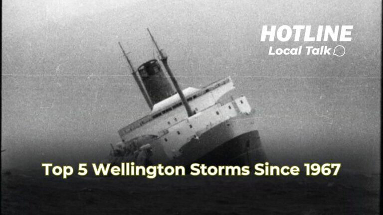
In April 1968, Cyclone Giselle collided with an Antarctic storm, creating New Zealand’s worst recorded tempest. On 10 April, winds in Wellington hit 275 km/h, with gusts tearing off 98 roofs in one suburb. Waves reached 12–14 metres, battering the inter-island ferry TEV Wahine. The ship, carrying 733 people, struck Barrett Reef, capsized, and sank near Steeple Rock. Tragically, 53 lives were lost to drowning, exposure, or injuries. Property damage reached $14 million, including destroyed homes in Kingston. Thus, the Wahine storm remains Wellington’s most devastating.
Transitioning to recovery, the nation mourned, and maritime safety reforms followed. However, Wellington’s stormy legacy continued.
The Great Flood – December 1976
Next, the 1976 storm unleashed chaos between 20–23 December. Heavy rain, exceeding 350 mm in 24 hours, triggered widespread flooding and landslides. The Hutt River burst its banks, forcing Petone workers onto factory roofs. In Crofton Downs, a collapsing wall killed a boy, marking one death. Landslips demolished homes, and infrastructure damage reached millions. Winds gusted up to 150 km/h, felling trees across the city. Consequently, the rainfall was the heaviest in 50 years, with some areas facing a once-in-500-year deluge.
Moreover, the storm exposed vulnerabilities in urban planning. Recovery efforts focused on reinforcing stopbanks and improving drainage, yet Wellington’s geography ensures ongoing risks.
The June 2013 Southerly
Fast forward to 21 June 2013, a fierce southerly storm battered Wellington with winds exceeding 200 km/h. Large waves destroyed Island Bay’s seawall, scattering debris across roads. In Owhiro Bay, carparks and roads crumbled under the onslaught. A fallen tree crushed a car in Johnsonville, but miraculously, no deaths occurred. Property damage included felled power lines, leaving thousands without electricity. The storm disrupted trains and toppled a supermarket sign. Financially, damages cost millions, with coastal infrastructure hit hardest.
Thus, the 2013 storm highlighted Wellington’s exposure to southerly gales. Community resilience shone through, with rapid cleanup efforts restoring normalcy.
Lowry Bay Boat Wreck – July 2022
In July 2022, a gale-force southerly, dubbed “Wahine weather,” wreaked havoc. On 21 July, winds of 140 km/h and waves up to 10 metres slammed a yacht off its mooring in Lowry Bay. The boat, a man’s home, smashed into the roadside, sustaining irreparable hull damage. All possessions aboard were lost, leaving the owner devastated. No fatalities occurred, but 28,000 homes lost power. A Lower Hutt slip threatened a residence, and flight cancellations stranded 600 passengers. Damages reached millions, with roads and rail services disrupted.
Consequently, the storm underscored the personal toll of extreme weather. Community support rallied to aid the boat owner, reflecting Wellington’s spirit.
May 2025 Tempest
This week, Wellington endured a severe storm on 1–2 May 2025, marked by red wind warnings and heavy rain. On 1 May, winds peaked at 140 km/h, with gusts threatening life, prompting MetService to issue a rare red warning, the first since 2019. Heavy rain, totalling 100–150 mm, caused flash flooding in low-lying areas. Large swells, reaching 8 metres, battered coastal roads, damaging Moa Point Road. Power outages affected 10,000 homes, and landslides closed State Highway 2. No deaths were reported, but property damage estimates exceed $5 million. Schools closed, and public transport halted as residents were urged to stay indoors. Conditions eased by 2 May, with recovery underway.
Therefore, the 2025 storm tested Wellington’s preparedness. Improved forecasting and warnings mitigated worse outcomes, yet vulnerabilities remain.
Predicting the Next Storm
Looking ahead, Wellington’s climate trends suggest intensifying storms. Rising sea levels and warmer oceans fuel stronger cyclones. Experts predict a major storm within the next decade, likely in autumn or winter. Winds could exceed 200 km/h, with rainfall surpassing 300 mm in 24 hours. Coastal suburbs like Island Bay face heightened erosion risks. Potential damages could top $20 million, with flooding threatening urban areas. However, advanced warning systems and reinforced infrastructure may reduce fatalities.
Thus, preparation is key. Wellington must invest in resilient designs and community readiness to weather the inevitable.
Conclusion
Wellington’s stormy history, from the Wahine tragedy to this week’s tempest, underscores its vulnerability. Each event, marked by fierce winds, towering waves, and costly damages, shapes the city’s resilience. The 1968 storm claimed 53 lives, while 1976’s floods and 2013’s gales tested infrastructure. The 2022 Lowry Bay wreck highlighted personal losses, and 2025’s storm disrupted daily life. Yet, Wellingtonians endure, adapting to their wild environment. Looking forward, proactive measures will mitigate future storms. For now, the capital stands firm, ready for whatever nature unleashes next.
TRUTH SEEKER
Instantly run a Quiz with friends... about the article. Interact more & analise the story. Dig in, catch out biased opinions, and "fact check" with TRUTH SEEKER by ONENETWORK WELLINGTONLIVE 👋
Do you agree with the main argument of this article?
Total votes: 8
Which storm caused the Wahine disaster in April 1968?
Bias Analysis
Fact Check Summary
False, the Wahine disaster occurred in April 1968.
Source: Article
True, the collapsing wall in Crofton Downs killed a boy.
Source: Article


